DECIFER_GEOGRAPHY_BOOK_MORMON.htm
NEPHITES lived in USA+CANADA BORDER=Great LAKES
.
To read in Portuguese
(para versão em Português)
click on: (clique sobre): http://www.oocities.org/asia/elywife/DECIFRANDO_GEOGRAFIA_L-MORMON.htm
Source (From): http://br.groups.yahoo.com/group/fotossud/message/1514
Date: Fri Jun 18, 2004
4:23 pm
Subject: BOOKmormon: it
is WRONG the "TROPICAL Geographic Version"
Also from: http://br.groups.yahoo.com/group/fotossud/message/1264
From: "SAVELLI =
SAB ELI = YHV (MY God)" <celsoely@y...> Date: Sun Mar 21, 2004 8:17
pm
Subject: NEPHITES lived around GREAT LAKES in the border of USA
and CANADA: hill Cumorah is a LAND MARK for MAPPING
Click on lower SMALL PICTURES (they enlarge) and then clic (again) in the right down corner (of some pictures) and then you can see
them very well enlarged.
 http://geocities.yahoo.com.br/rio_eden/L_MORMON_NEFITAS_TROPICAIS.jpg
Typical LDS authorities
and members "believe, have faith" NEPHITES lived in South Mexico,
probably in GUATEMALA. Thus they "teach" that in all means possible,
as JESUS CHRIST landing in front of a PYRAMID!
WE ARE TO EVALUATE ("SEE") THE WHOLE
ROUTE FOLLOWED BY LEHI´S GROUP
SINCE JERUSALEM UP TO GREAT LAKES (and hill CUMORAH,
end of NEPHITES)
http://www.oocities.org/celsoelyi/LIGACAO_ENTRE_NEFITAS_JAREDITAS.htm
YOU NEED TO TYPE http
in ADDRESS BAR before such URL and press ENTER. What are connections/LINKS
between the people Jaredites and NEPHITES?
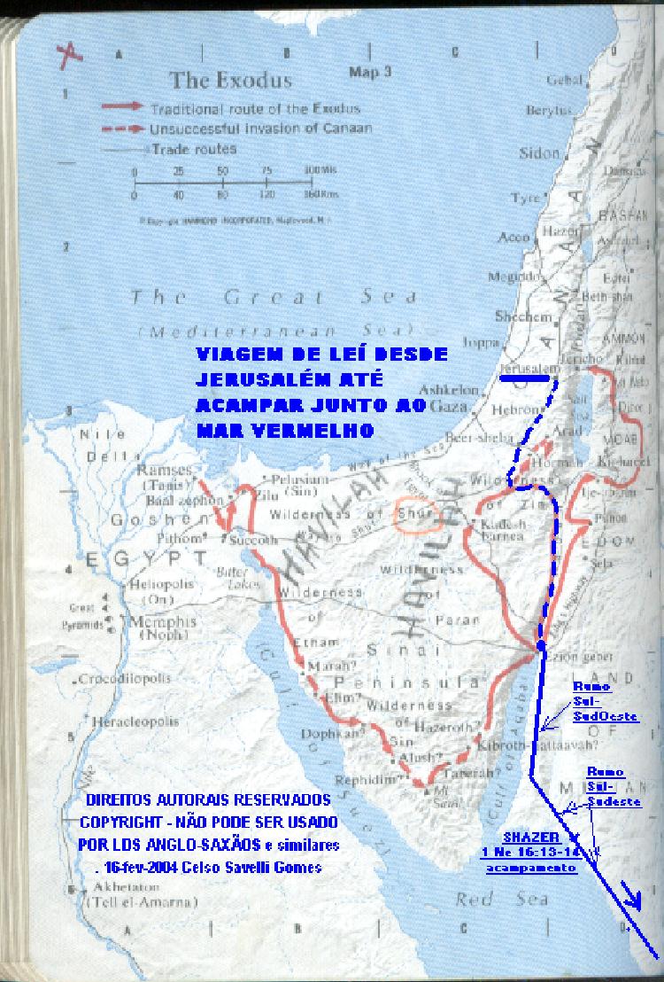 http://www.oocities.org/celysg/LEHI_JERUSALEM_MAR_VERMELHOin.jpg
IT IS THE START OF LEHI´s TRIP from
JERUSALEM and going toward the RED SEA. You may enlarge picture clicking over
right down edge of it. The route is in BLUE LINE through a traditional road and
then followed a pathway used in EXODUS, going to very ancient and traditional
harbor of Israel (as in Solomon´s) in EZION-GEBER, where they
"camped" for many days before traveling along GULF of AQABA and then
along RED SEA I used MAP 3 from LDS book having Holly Bible to Pearl of Great
Price
 http://www.oocities.org/celysg/LEHI_JERUSALEM_MAR_VERMELHO.jpg
QUITE SIMILAR MAP, of
such first portion of LEHI´s caravan to Red Sea
 http://www.oocities.org/celysg/LEHI_JERUSALEM_MAR_VERMELHOam.jpg
Similar and BROADER
view. If you click right down corner it enlarges.
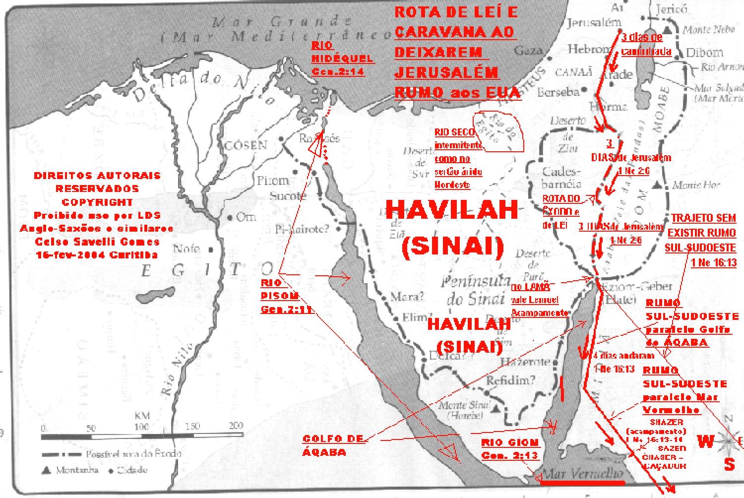
 http://www.oocities.org/celysg/SAIDA_AQABA_detalhe.jpg
River LAMAN and Valley LEMUEL: it is
shown where they were, and also the camping where they stayed for so many days
before continuing the travel. SHAZER is a corruption (due frequent PHONETIC translation by Joseph Smith
in Book of Mormon, from Sabelli´s like language...) of CHASE(R),
"hunt" , originated from old Sabelli´s=Lehi´s language. Since that
point (shown in maps), they had not more stored provisions from Jerusalem, thus
they had to survive "HUNTING"=SHAZERs as it is clear in 1
Ne.16:13-14. SHAZE(r) =CHASE(r) phonetically=HUNT. 1 Ne 16:13 nearly a south-southeast
direction, exactly as shown in MAPS...
The maps, with LINKS
(URL) given in this message, presents the path (route) since JERUSALEM up to
the RED SEA (as above maps), and then the route had a path bordering parallel
the RED SEA (South-Southeast) up to arrive in MECCA, where I guess they had to
deviate (due high mountains and difficult crossing them, toward YEMEN) to EAST.
As a cattlemen, they raised CAMELS during 8 years,thus they were so plenty of
MILK, just to train and be ready to cross the DEADLY and LONG desert, all the
days toward EAST, in a VERY SHORT TIME (that is the practice, as if a "cat
crossing a hot roof of zinc: in a hurry") and to have enough animals to
cross hot soft sinking sand with windblows. They arrived in BAY BOUNTIFUL,then
an OASIS (dryed rivers can be seen in satelite pictures, as some added here,
some in so great details... At end of 8th year (wandering slowly to EAST) they
fast moved 20º36´N
 http://geocities.yahoo.com.br/rio_eden/LEHI-JERUSALEM-MECAred.jpg
You can enlarge CLICK right lower
corner picture. In top right side, in middle left side and in bottom side. It
is shown in "GREEN" the path route LEHI´s caravan followed in ARABIC
PENINSULA. Up to BOUNTIFUL.
http://geocities.yahoo.com.br/rio_eden/LEHI-JERUSALEM-MECA.jpg
It is the same above picture, but
greatly enlarged for you see details. But don´t forget to click on picture
lower right corner to big enlarge it In map middle left side you can see LEHI´s
departure from BOUNTIFUL!
 http://geocities.yahoo.com.br/rio_eden/CAMINHO_LEHI_ARABIAred.jpg
See the EAST TRAVEL of LEHI´s
caravan since RED SEA (MECCA) to BOUNTIFUL.
 http://geocities.yahoo.com.br/rio_eden/CAMINHO_LEHI_ARABIA.jpg
It is SAME PICTURE above, but now
very enlarged. CLICK right down corner...
 http://geocities.yahoo.com.br/celsoelyi/-SPACE_SHUTTLE.jpg
Nowadays it is possible to see
ABUNDANCE even from SPACE STATION, as here... Click right down corner to have
enlarged view of BOUNTIFUL from space (BOUNTIFUL=ABUNDANCIA= is in GULF OF
MASIRAH, near Island of MASIRAH)
 http://www.oocities.org/celysg/ABUNDANCIA_SATELITE_250M.jpg
POINTED BAY is BOUNTIFUL
(ABUNDANCIA). Click on down right corner of picture and it enlarges and you can
see hugest details of BOUNTIFUL and BAY. With enlarged picture, move it full to
right and a little down! SEE!
You can SEE the details
of BAY and HARBOR in BOUNTIFUL, where a SAIL SHIP (as those used to discover
AMERICA...) was built and put to SAIL (smoothly) not in storm weather: then
WINDS follow the coast of AFRICA and they had a SMOOTH FAST trip, but reached
extreme of SOUTH AFRICA (CAPE of TORMENTS) were they "suffered great
fears" (all SAIL CLOTHS REMOVED and TIED with so many and STRONG ROPES...
ropes were not to "tie" NEPHI... but to "SAIL"). With
better weather and winds they were moved to coast along AFRICA, far from BRAZIL
coast, up to a point they moved (with winds) directly to NEW YORK (LONG
ISLAND).
 http://geocities.yahoo.com.br/celysg/VENTOS-LEHI_a.jpg
SEE THE MAPS OF WINDS, to understand
LEHI´s travel to USA (N.YORK) in a fast way, in a not big SAIL SHIP (this was
more for passenger). Examining data available, it appears they arrived in
N.York (Long Island) probably in late SPRING TIME (maybe in early SUMMER). We
can see, in the upper part of such map, the JAREDITES departed from a very huge
and old HARBOR and good BAY in RUSSIA (it is all the way NORTH Babel TOWER) with
HUGE CARGO SAIL SHIPS FLEET, transporting HUGE AND HEAVY CARGO, to N.YORK ALSO
to LONG ISLAND, a kind of "SANCTUARY" for experiments and my guess is
also they arrived in SPRING or early SUMMER time. Examining the maps of WINDS
it appears almost impossible, or very difficult,they had departed in Winter time;instead
traveled in SPRING
 http://geocities.yahoo.com.br/celysg/NOVO_ATLAS_red.jpg
IT IS ANOTHER TYPE OF WORLDWIDE
WINDS and WEATHER conditions. You can see easily the WHOLE TRIPS of JAREDITES
(since BABEL), in upper part (green in land) and LEHI (since Jerusalem): also
green and then BLUE and you can click on right down corner to see routes very
enlarged.
 http://www.great-lakes.net/gis/maps/24a_small.gif
They arrived in LONG ISLAND (New
York) from there both people (LEHI´s and JAREDIT's´) moved to CONTINENT and
penetrated along the RIVER HUDSON, mining it (in fact, so many mines abandoned
are known along it, even gold) and going to its head, they penetrated into
GREAT LAKES: their HOMELAND.
 http://www.great-lakes.net/gis/maps/glakes_sm.gif
SATELITE PICTURES OF GREAT LAKES. Lake
most right, ONTARIO LAKE,has in the middle part and down of it, some like
"scratches" (small lakes) and amont of them is HILL CUMORAH and
continuing down and right is town NEW YORK. The great lake in down and left
part is LAKE MICHIGAN, and at the lower extremity is CHICAGO TOWN, start of
Illinois River, where a NEPHITE (WHITE PERSON) who joined LAMANITES (at defeat
of Nephites) and became "WHITE" LAMANITE (white due "race",
LAMANITE=CITIZENSHIP) and such body was found by JOSEPH SMITH in a trip with
his followers. You can see the WAR TOOK PLACE AROUND "GREAT
LAKES",for JAREDITES and also for NEPHITESxLAMANITES and maybe will erase
BAD GENTILES there! The connection of two lakes in right down is NIAGARA
FALLS:USAxCANADA
Connection 2 lakes in
middle is the RIVER SIDON: so great wars in it! A very STRATEGIC PLACE to
control "heavy SAILSHIPS navigation G.LAKES
 http://www.oocities.org/elywife/PROFETA/NEPHITESgLAKES.jpg
CLICK the right down corner picture to see it enlarged: like satelite picture. Have in mind that JEWS used "SEA" for BIG FRESH WATERS,as SEA Galilee LAKE ONTARIO was EAST SEA of BOOK OF MORMON... The arrow down LAKE MICHIGAN is the RIVER ILLINOIS starting around RED CIRCLE=CHICAGO and you can see JOSEPH SMITH found a run-away WHITE NEPHITE turned LAMANITE´s CITIZEN, who survived the war of extermination NEPHITES...
WE WILL EXAMINE 3 NEPHI Chapter 8. FOR SURE, this narrow passageway, in NIAGARA FALLS (BUFFALO TOWN, border of USA and CANADA) allows communication between the lands at the "north" of Lake Ontario and Lake Erie with the other lands at the "south" of such 2 lakes. Thus was a VERY STRATEGIC place/land for NEPHITES and LAMANITES. And thus had good towns in it: to secure its possession (control) for military and commercial (business) reasons. We can speculate that one or more of such towns, built in high elevation but next to the high margin of LAKE ONTARIO (like BUFFALO TOWN), "fell" (as old "River Sidon" waters flowed/flows in nowadays huge "FALL": through "NIAGARA FALLS") into such LAKE ONTARIO during an earthquake (and/or MORE PROBABLY due underneath WAVE EROSION, as caused by HUGE LAKE ONTARIO WAVES waves due earthquakes AND MAINLY DUE to HUGE HURRICANE WINDS that cause so HUGE WAVES HEIGHT and destructive water erosion power in BIG SEA (LAKE ONTARIO)... Waves broked weak SEDIMENTARY rocks, maybe some type of sandstone-gravel very erosible, under a cover cap of stiff rock difficult to erode (limestone? basalt? I didn't paid attention when I went there for tourism): that is usual in generating some tall big waterfall... I worked in the design of some quite big brazilian dams...). 3 Nephi chapter 8: thus such towns and people were "SANK" INTO SUCH huge "SEA" (fresh water "SEA = Lake Ontario", very similar to "SEA of GALILEE" in Israel, and many other "sank" due flooding by HUGEST WAVES caused by HURRICANE, quite like WAVE which flooded NEW YORK in the recent movies THE DAY AFTER TOMORROW...). And also some fell (from tall margin of LAKE ONTARIO) on dry ground and more landslide covered them with more earth and stones (from further land sliding). As houses were made of wood (plenty of forestes and wood is best for good thermal insulation with double wall... living place during wintertime) over a stone foundation and walls (with such underneath floor for food and goods storage, as for use in agriculture, in mining, for personal and collective wars, etc.), it is easy to understand that broken houses of dry wood got into fire easily and fast (as TOKYO in an old and great earthquake). In South of Brazil, with heavy European and recent immigration, from most traditional (rural) places of Europe, such type of homes (STONE + WOOD) are yet in use, as in Parana State and even Curitiba... Examine a good site about HEIGHT of WAVES and "HUGE WAVES" (up to 30m height!!!) as related to the maximum length of lake ("SEA", as mentioned in SEA GALILEE with a JESUS' myracle...) along HURRICANE wind direction (for sure HURRICANE WIND was blowing from EAST to WEST, in 3 Nephi chapter 8: just examine position of NIAGARA FALLS and the main fetch in Lake Ontario is from East to West...) and HURRICANE WIND speed velocity and other factors (as water depth). "Learn" about HUGE WAVES! http://www.seakayak.ws/kayak/kayak.nsf/NavigationList/NT0000C07A and next related (linked) sites
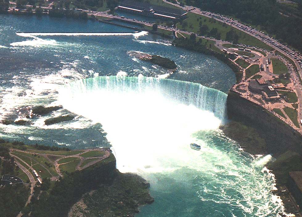 SEE THE IMPRESSIVE HIGHT OF WATER FALLING FROM the "palisades" into LAKE ONTARIO through the place where takes place the WATERFALL which yet is ERODING (to upstream) the soft rocks and making the WATERFALL move to the start of OLD "RIVER SIDON" (LAKE HURON and MICHIGAN and SUPERIOR) in almost one meter, because the inferior rocks are very erodible (weak). To avoid any such problems, most of the water do not pass through the WATERFALL, but through turbines to generate ELECTRICITY. Thus waterfall has made stable in nowadays position. But in some thousand years the waterfall position changed very fast huge quilometers distance eroding soft rocks. I worked in design of some large Brazilian dams.
trabalhei em projetos de (grandes) barragens brasileiras... The most beautiful and tourist worldwide WATERFALLS are in the border of Brazil and Argentina, in Brazilian town FOZ DO IGUAÇU. Such waterfall is very stable for huge geologic time as it is based on very resistent rocks (basalt). Geologically the waterfall of
NIAGARA is very "ultra-recent" and "unstable". Click on picture and it enlarges and move it down and right for you see a tourist boat (Maid of Mist?) sailing almost under the FALL: I did such tourism in USA. It is equally available in Brazilian IGUACU FALLS (much more beautiful and in exotic/tropical paradise).
SEE THE IMPRESSIVE HIGHT OF WATER FALLING FROM the "palisades" into LAKE ONTARIO through the place where takes place the WATERFALL which yet is ERODING (to upstream) the soft rocks and making the WATERFALL move to the start of OLD "RIVER SIDON" (LAKE HURON and MICHIGAN and SUPERIOR) in almost one meter, because the inferior rocks are very erodible (weak). To avoid any such problems, most of the water do not pass through the WATERFALL, but through turbines to generate ELECTRICITY. Thus waterfall has made stable in nowadays position. But in some thousand years the waterfall position changed very fast huge quilometers distance eroding soft rocks. I worked in design of some large Brazilian dams.
trabalhei em projetos de (grandes) barragens brasileiras... The most beautiful and tourist worldwide WATERFALLS are in the border of Brazil and Argentina, in Brazilian town FOZ DO IGUAÇU. Such waterfall is very stable for huge geologic time as it is based on very resistent rocks (basalt). Geologically the waterfall of
NIAGARA is very "ultra-recent" and "unstable". Click on picture and it enlarges and move it down and right for you see a tourist boat (Maid of Mist?) sailing almost under the FALL: I did such tourism in USA. It is equally available in Brazilian IGUACU FALLS (much more beautiful and in exotic/tropical paradise).
 http://www.oocities.org/asia/elywife/NIAGARA_FALLS_USAxCANADA.jpg
 http://www.oocities.org/celysg/17.jpg
 Here it is shown the arrival of
SAILSHIPS in NEW YORK and their penetration through River HUDSON up to GREAT
LAKES (in case, LAKE ONTARIO): where is HILL CUMORAH. It is to CLICK right down
corner of picture to examine it very enlarged
 http://www.oocities.org/celysg/DETROIT_AMPLIADO1tela.jpg
So great WARS BATTLE took place in
the river SIDON, connecting LAKE ERIE and LAKE HURON (and thus LAKE MICHIGAN
and SUPERIOR), because of its so great STRATEGIC POSITION (there is a very
narrow neck in river) to control NAVIGATION (BIG SAIL
SHIPS),COMMERCE,MILITARY,occupation,etc
 http://www.oocities.org/celysg/DETROIT_SATELITE_AMPL_1tela.jpg
THIS IS LIKE PREVIOUS PICTURE, but
now from SATELITE PICTURE, importance in extreme for military (and many towns
around battle fields) and for NAVIGATION (or to charge "rights of
travel", as in river Rhine...). CLICK on right down corner to see satelite
picture very enlarged. YOU can see RIPLAH is almost in front of nowadays town
of DETROIT... You can see where sank the bodies of dead soldiers:into LAKE
ERIE=no flow
 http://www.oocities.org/celysg/DETROIT_SATELITE_AMPL_4telas.jpg
THIS is the previous satelite
picture, but now VERY ENLARGED. CLICK on the right lower corner of picture to
see it very enlarged and move it all the way right and you see EXIT of HURON
LAKE (start SIDON RIVER) and then move down and see the course of RIVER SIDON
up to LAKE ST. CLAIR and then the NARROW NECK of RIVER SIDON in front of HILL
RIPLAH and see the BATTLE FIELD, very nicely described in BOOK OF MORMON. You can
see such main events with corresponding Scripture; their BURIAL ORIGIN OF
JAREDITES: From the TOWER OF BABEL, in a place nearby BAGDAH,in IRAQ. They
moved all the way NORTH:THUS TO nowadays RUSSIA
 http://geocities.yahoo.com.br/celysg/DISPERSAO_BABEL_JAREDEred.jpg
Click on right lower
corner of picture to see it enlarged. It starts JAREDITS pathway around BAGDAH
and moved straight line NORTH from it to a place where we could make HUGE HEAVY
SAIL SHIPS: in RUSSIA!!! It was used as SAIL SHIP HARBOR (first of Russia...)
in a GOOD BAY. You can see the ROUTE FOLLOWED BY SAILSHIPS OF JAREDITES TO
N.YORK.
 http://geocities.yahoo.com.br/rio_eden/PORTO_JAREDITA_BABEL.jpg
CLICK on right lower
corner of picture to see it enlarged. The green line comes all the way NORTH
from BABEL TOWER, and arrives in this very good HARBOR for huge SAILSHIPS (used
by Russia, centuries ago) and then followed the RED LINE navigating (not in
WINTERTIME: ICE) toward AMERICA CONTINENT (quite like Vickings) reaching NEW
YORK.
For those who only
believe the NEPHITES, LAMANITES and JAREDITES lived in TROPICAL LANDS (almost
NAKED was only for battles, in WARMER parts of year: war time, to have GREAT
MOBILITY for fight) there is somehting for you think about other options:
http://www.utlm.org/onlineresources/zelph.htm
Zelph - The White
Lamanite Warrior by Sandra Tanner "THINK ABOUT!"
Today Many of the LDS
scholars want to limit the Book of Mormon geography to southern Mexico and
Guatemala. However, the leaders of the LDS Church have always maintained that
the story happened over the larger land mass of North and Central America. One
of the problems of limiting the geographic area of the Book of Mormon to southern
Mexico is the purported finding of the burial of a Lamanite warrior in
Illinois. If Joseph
Smith was correct in identifying this skeleton then the Book of Mormon battles
must have happened in North America.
OK. THIS WORK, OF THIS MESSAGE, SHOWS WHERE THEY LIVED AND
THEIR BATTLES AND COLONIZATION EFFORTS. ONLY A PORTION OF THE MATERIAL IS SHOWN HERE. MANY OTHER PARTS WERE ALREADY POSTED IN BRAZIL AND
EVEN IN SO MANY LDS ("NOT SO BIASED", AS USUAL with SAXON LDS:it is
easier to publish something in JUDAISM SITE than in their SALTY sites...)Ex.
Date: Wed, 16 Jun 2004
03:30:39 -0000
From:
"kmsiever" <kim.siever@u...>
To: "SAVELLI = SAB
ELI = YHV (MY G-D)" <celsoely@y...>
Subject: Message_not_approved:_BUSH=symbolism_DANIEL´s_statue=WTC_symbolism_TERROR
[This message is
unrelated to the Church of Jesus Christ of Latter-day Saints in Canada. --Mod]
SHALOM! SAVELLI (AL_IJAH)