The explanations of FIGURES and MAPS and PICTURES you are to read in
BRAZILIAN PORTUGUESE LANGUAGE in such sites. At the end of message 1531
it was written a very specific "MESSAGE" to "whites" of North America
(in the way they live as WASP, including LDS) about fate of NEPHITES
and maybe themselves will repeat/face what the Nephites did:
http://www.oocities.org/asia/elywife/ALGUEM_BOM_VIROU_DARK_SIDE.jpg USA
GOVERNMENT is turning into (more and more) the "DARK SIDE": yet there
is a good person under the "head cover".But Evil has domain over him
and order his acts (as IRAQ invasion). If your NATION+LDS decides to
support him, as in free election, You are to join also the "DARK SIDE
(as NEPHITES did...)". Because You know about his behavior and ideas.
You are as ADAM (knowing what is WRONG...) and if support him, AGAIN:
God BLESS You to SURVIVE in DARK SIDE.USA was to provide TRUE FREEDOM
The GEOGRAPHY presented in BOOK OF MORMON is for YOU, USA CITIZENS...
http://www.oocities.org/asia/elywife/Seaway_SLSMC_Glakes.JPG
http://www.oocities.org/asia/elywife/NIAGARA_RODOVIARIO4.JPG
http://www.oocities.org/asia/elywife/NIAGARA_RODOVIARIO4a.JPG
http://www.oocities.org/asia/elywife/NIAGARA_RODOVIARIOsidonR.JPG
http://www.oocities.org/asia/elywife/NIAGARA_RODOVIARIOsidonR1.JPG
http://www.oocities.org/asia/elywife/NIAGARA_RODOVIARIOsidonR2.JPG
http://www.oocities.org/asia/elywife/NIAGARA_RODOVIARIOsidonR3.JPG
http://www.oocities.org/asia/elywife/ALGUEM_BOM_VIROU_DARK_SIDE.jpg
END of http://br.groups.yahoo.com/group/fotossud/message/1531 Drawings
Pictures/figure are in sequence as in such GROUP. Use Translator.
***************************
http://www.oocities.org/asia/elywife/ESCUMAS.JPG Picture of this writer
making experiments with flotation of SEWAGE SCUM for design a plant.
I don't know even about HUMAN MANURE (need to make research): could I
know any detail about GEOGRAPHY presented in Book of Mormon?
http://www.great-lakes.net/conditions/stclair.html
http://www.great-lakes.net/lakes/stlaw.html
http://www.glrc.org/story.php3?story_id=2314
END of http://br.groups.yahoo.com/group/fotossud/message/1530
****************************
http://www.oocities.org/asia/elywife/UNIAO_MAR_LESTEaoOESTE.htm
http://www.oocities.org/asia/elywife/NIAGARA_RODOVIARIO.JPG
http://www.oocities.org/asia/elywife/NIAGARA_RODOVIARIO2.JPG
http://www.oocities.org/asia/elywife/NIAGARA_RODOVIARIO3.JPG
http://www.oocities.org/asia/elywife/NIAGARA_RODOVIARIO4.JPG
http://www.oocities.org/asia/elywife/NIAGARA_RODOVIARIO5.JPG
http://www.oocities.org/asia/elywife/NIAGARA_RODOVIARIO6.JPG
END of http://br.groups.yahoo.com/group/fotossud/message/1529
**************************
http://www.oocities.org/asia/elywife/UNIAO_MAR_LESTEaoOESTE.htm
THIS IS THE MAIN SITE TO DISCUSS ABOUT NIAGARA FALLS and NIAGARA
RIVER as that NARROW LAND STRIP BETWEEN "WEST SEA" (LAKE ERIE) AND
THE "EAST SEA" (LAKE ONTARIO), some 35 km of distance that a person
could walk in some 1 day (maximum 1.5 day in worst guess...), in
shortest path. NIAGARA RIVER length is 57 km and water level diffe-
rence is about 100m between such "SEA" (half that in Niagara FALLS).
http://br.groups.yahoo.com/group/fotossud/message/1527
************************
http://www.oocities.org/asia/elywife/DECIFER_GEOGRAPHY_BOOK_MORMON.htm
is the GEOCITIES FILE in ENGLISH, updated (revised) and full with
miniature PICTURES (that enlarge just making a CLICK on them).
WARNING: nowadays the most well updated (general) file is in
PORTUGUESE, the one with URL presented next. Use a TRANSLATOR GOOGLE.
http://www.oocities.org/asia/elywife/DECIFRANDO_GEOGRAFIA_L-MORMON.htm
In them (Portuguese and English) You will find something added and
what is about the beginning of Chapter 3 of 3rd.NEPHI.
http://www.oocities.org/asia/elywife/NIAGARA_FALLS_USAxCANADA.jpg
http://br.groups.yahoo.com/group/fotossud/message/1526
***********************
http://br.groups.yahoo.com/group/fotossud/message/1522 THE 10 CLUES
TO BETTER UNDERSTAND/JUDGE the "GEOGRAPHY" presented in BOOK of MORMON
************************
http://br.groups.yahoo.com/group/fotossud/message/1520 TERROR to USA
How affects FREEDOM of RELIGION+personal (the message is in ENGLISH)
TERROR to USA How affects FREEDOM of RELIGION+personal
IN THIS SITE (click next)
http://www.oocities.org/asia/elywife/USA_PREVENTS_LDS_IN_ISLAMIC.htm is
WHERE FULL SITE IS.It is about "TERRORism" to USA (why?) and related
lack of "RELIGIOUS FREEDOM in ISLAMIC NATIONS": because USA controls.
http://www.hrw.org/press/2003/10/saudi102903.htm
Saudi Arabia: Arrest of Protesters Belies Reform Pledges
http://hrw.org/press/2003/07/saudi070203.htm
http://www.hrw.org/press/2003/06/saudi061903.htm
http://www.hrw.org/doc?t=mideast&c=saudia
*********************
http://www.utlm.org/onlineresources/zelph.htm "Zelph - The White
Lamanite Warrior" by Sandra Tanner Today
Many of the LDS scholars want to limit the Book of Mormon geography to
southern Mexico and Guatemala. However, the leaders of the LDS Church
have always maintained that the story happened over the larger land
mass of North and Central America. One of the problems of limiting the
geographic area of the Book of Mormon to southern Mexico is the
purported finding of the burial of a Lamanite warrior in Illinois. If
Joseph Smith was correct in identifying this skeleton then the Book of
Mormon battles must have happened in North America.
http://geocities.yahoo.com.br/rio_eden/L_MORMON_NEFITAS_TROPICAIS.jpg
CARTOGRÁphic STUDIES OF HOW LEHI travelled from Jerusalem to USA:N.Y.
http://www.oocities.org/celsoelyi/LIGACAO_ENTRE_NEFITAS_JAREDITAS.htm
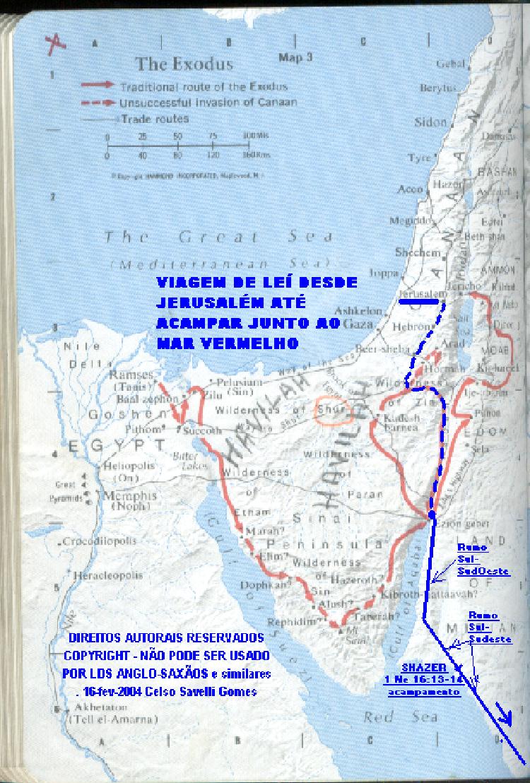
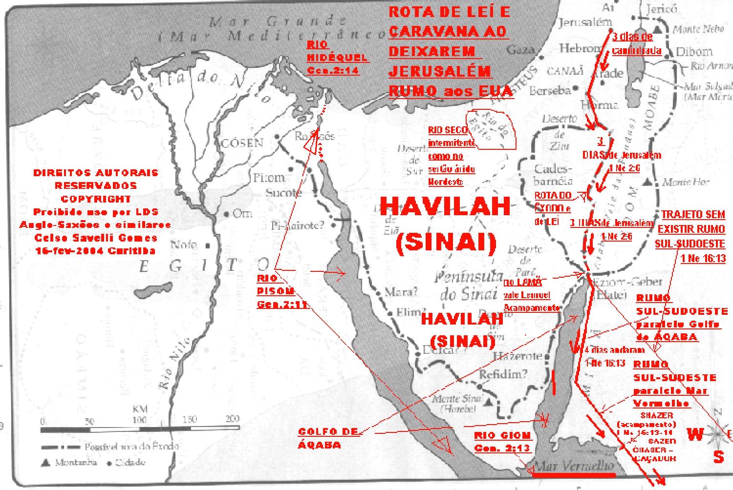
http://www.oocities.org/celysg/LEHI_JERUSALEM_MAR_VERMELHOin.jpg
http://www.oocities.org/celysg/LEHI_JERUSALEM_MAR_VERMELHO.jpg
http://www.oocities.org/celysg/LEHI_JERUSALEM_MAR_VERMELHOam.jpg
http://www.oocities.org/celysg/SAIDA_AQABA_detalhe.jpg
http://geocities.yahoo.com.br/rio_eden/LEHI-JERUSALEM-MECAred.jpg SEE
LEHI's route: in 3 lines "GREEN" on map (at right, left and bottom)
http://geocities.yahoo.com.br/rio_eden/LEHI-JERUSALEM-MECA.jpg
http://geocities.yahoo.com.br/rio_eden/CAMINHO_LEHI_ARABIAred.jpg
http://geocities.yahoo.com.br/rio_eden/CAMINHO_LEHI_ARABIA.jpg
http://geocities.yahoo.com.br/celsoelyi/-SPACE_SHUTTLE.jpg BOUNTIFUL!
http://www.oocities.org/celysg/ABUNDANCIA_SATELITE_250M.jpg
http://geocities.yahoo.com.br/celysg/VENTOS-LEHI_a.jpg LEHI's WINDS!
http://geocities.yahoo.com.br/celysg/NOVO_ATLAS_red.jpg
http://www.great-lakes.net/gis/maps/24a_small.gif ÁREA GERAL NEFITAS
http://www.great-lakes.net/gis/maps/glakes_sm.gif Satelite of G.LAKES
http://www.oocities.org/elywife/PROFETA/NEPHITESgLAKES.jpg nephi rout
http://www.oocities.org/celysg/17.jpg ROUTE TO ARRIVE INTO Great LAKE
http://www.oocities.org/celysg/DETROIT_AMPLIADO1tela.jpg BATTLE lands
http://www.oocities.org/celysg/DETROIT_SATELITE_AMPL_1tela.jpg sateli
http://www.oocities.org/celysg/DETROIT_SATELITE_AMPL_4telas.jpg large
ORIGIN JAREDITES:from near BAGDAH=left(BABEL) moved NORTH to "HARBOR"
http://geocities.yahoo.com.br/celysg/DISPERSAO_BABEL_JAREDEred.jpg
http://geocities.yahoo.com.br/rio_eden/PORTO_JAREDITA_BABEL.jpg HARBOR
FOR SURE, THERE ARE MUCH MORE SITES, WITH PICTURES, MAPS, GRAPHS,
DISCUSSIONS, MESSAGES, etc. about the TOTAL PATHWAY of JAREDITES and
LEHI's DESCENDENTS, since their ORIGIN in BABEL's TOWER (JAREDITES)
and JERUSALEM (and MECCA, as ISMAEL was of Ismael's religion,Esaiah)
their ROUTES OF TRAVELLING (INCLUDING OF MAKING "SAIL SHIPS" AND
"SAILING" through OCEAN/"SALTY SEAS", up to AMERICA CONTINENT, arri-
ving in the GREAT ISLAND (LONG one) where today is New York town. In
such ARRIVAL PLACE there is a good teaching for those who UNDERSTAND.
SHALOM!
AL_IJAH (savelli)
MESSAGE as sent to: http://espanol.groups.yahoo.com/group/MormonesIberoamericanos/message/17
De:
"CELSO SAVELLI GOMES" <celsoelyi@y...>